Dune crossovers + wind pits

Landscape Plan Maasvlakte 2

The objective of the Port Authority was to extend the port area through expansion of the Maasvlakte, combined with the creation of space for recreation and nature. The Maasvlakte is increasingly developing as an important site for natural and recreational activity.

Motive

365 million cubic metres

To realise their ambitions for growth and development, and to give shape to the Port of Rotterdam, the Port Authority developed a plan for westward expansion. The expansion commenced in 2008 and used approximately 365 million m 3 of sand. In 2013, the Maasvlakte 2 Project commenced operation.

Outer contour

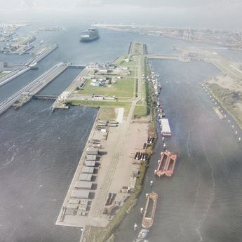
The expansion of Maasvlakte 2 is designed to accommodate for ship activities in container and chemical distribution. The expansion measures 2000 hectares, half of which is allocable for port-related activities. The remaining section consists of infrastructure, the seawall and other amenities, grouped in the so-called ‘outer contour’. H+N+S prepared the landscape plan for this ‘outer contour’.

In addition to the functionality of the port, there are other important considerations in the design of the Maasvlakte 2

The functionality of the working port is paramount, however there are also other important considerations in the design of the Maasvlakte 2. Three primary characteristics of the port can be identified – the technical, functional aspect of the port; the natural harbour; and the creation of an accessible recreational site. The landscape plan for the main structure of Maasvlakte 2, integrates these three themes into a single, unified design.

Approach

Reconnaissance

For the establishment of this new piece of ‘harbour landscape’, H+N+S Landscape Architects, in collaboration with BSR (Bureau Urban Nature, Rotterdam), prepared a reconnaissance study in April 2006, commissioned by the Maasvlakte 2 Project Organisation – part of the Port of Rotterdam. Parts of this study have been incorporated into the final Project Plan for Maasvlakte 2.

Elaboration

In 2009 and 2010, this initial research was expanded into a Landscape Plan which, itself, was divided into parts. One of the parts considered the effect on the entrance area to the Port during the transition from Maasvlakte 1 to Maasvlakte 2. Another part considered the implications involved in the realisation of the B-Node (one of the dune crossovers). Futhermore, the Plan considered the development of the ‘South Point’ area and parking facilities at the beach.

Concept map Maasvlakte 2

Result

As previously mentioned, three primary considerations were identified in the design for the Maarsvlake 2: the technical or functional capacity of the Port; the natural harbour; and the creation of an accessible and attractive Port. In the Landscape Plan, these three aspects were integrated into one innovative concept, and explored in detail. The design featured a sturdy, tough landscape to suit the vast scale of the project, with long sight lines, robust viaducts, an accessible beach designed for intense public usage and large car parks.

Natural processes

The natural landscape is delicately and precisely composed and thus, while the outer contour forms part of the design plan, there is scope for the influence of natural processes (such as erosion and dune formation) to create the final shape. The influence of these processes is carefully monitored, and viewing platforms have been installed to highlight the contrast between the natural dunes and the port landscape.

Landscape plan

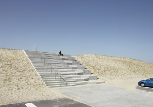
Dune crossovers

The major components of the landscape plan are focussed in the outer contour of the design, rather in the natural dunes and the infrastructure areas. An infra-beam separates the largely-natural outer contour, and the functional port which is harboured in the sheltered inner-contour. The dune crossovers serve as ‘intermediaries’ - recognisable landmarks, which unite the natural dune landscape, the functional port and recreational port. The dune crossovers are to be designed by Zwarts Jansma Architects.

Scenic route

On the outer contour, the infrastructure areas are meticulously designed to ‘play’ with the factors such as, amongst others, the difference between left and right, elevation and vistas. These areas, built on the scale of hundreds of metres or even kilometres, will be composed of asphalt, concrete and sand.

Impression 70m high dunes

Harbour views

The design includes a number of vistas, with views of the natural landscape of dunes and the North Sea, but also of the landscape of the working Port. There are three lookout points integrated into the planned terminals, namely at the head of the harbour basins. To ensure that there are uninterrupted sightlines to the docks, restrictions on the height of buildings have been implemented.

Spontaneous nature

Much attention in the landscaping plan has been dedicated to the natural qualities of the site. The challenge is to ‘channel’ or maximise the spontaneous qualities of the natural environment, in the context of an integrated and functional design for Maasvlakte 2.

Various ecotypes in 'outer contour'

Profiling dunes

The design of the dunes is based on the development of a semi-natural dune landscape. Thus, the dunes are made through the use of civil engineering techniques, fixed with dune vegetation, while also allowing for nature to be given free rein to organically develop (wind erosion and sedimentation).

Wind pits

This natural development has been achieved by sharing, and not overwhelming, the landscape: locally, oval shaped areas have been left open and function as so-called ‘wind pits’. These wind pits naturally disseminate the sea spray, which relieves wind pressure on the dunes and stimulates the development of natural beach vegetation.

Parking

Birds

The introduction of a soft seawall with the right kind of sand, creates favourable conditions for certain plant and animal species to flourish. The sheltered inner-contour will gradually become overgrown with shrubs (including buckthorn and elderberry), creating a habitat for breeding birds (various songbirds). Dry dune grasslands may also develop further inland, between recreational trails, roads and parking lots.

Parking facilities

The parking facilities at the beach are designed to hold a large capacity of public attendees (1500 parking spaces). Each parking area is located in a cove of the dunes, which maximises the functional, sturdy character of these areas. By shaping the parking spaces as man-made interventions within the semi-natural dune landscape, the dual functional and natural qualities of the Maarsvlakte 2 are emphasised.